- Description
- Additional information
Description
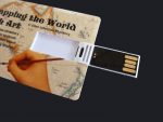
This format contains everything you need on a 64 GB USB memory drive. You get a PDF copy of the textbook (you can print out any pages you’d like to), a folder of supplemental map images, and a folder with all the videos of the drawing lessons. (NOTE: You can move the files to your computer desktop, but please respect copyright and don’t distribute any files to people outside of your family, classroom, or homeschool group.) As an added bonus, the drive also has about 20 GB of storage you can use!
If you would like a hard copy of the book, I do have an option for ordering just the book (“extra copy” option). You can also order the book on your favorite book selling websites such as Amazon, BookDepository, BooksAMillion, Barnes & Noble, etc.
FREE SAMPLES:
Click here to download the first three chapters (history, drawings, activities)
Click here to download the table of contents
Click here to see the video lesson for drawing 1
Click here to see the video lesson for drawing 2
Click here to see the video lesson for drawing 3
*************************************************************
Age group: 10-16 (history text and drawing lessons are appropriate for over 16, or even adult learners)
Structure of curriculum: This curriculum is in 3 parts:
1) Part 1 contains 30 short history lessons. Each lesson is one double-sided page. The writing is straightforward and easy to understand and is accessible to younger students, but it does not have a patronizing “written for kids” tone, and thus is appropriate reading for older students as well. The drawing lessons and activities are based on the themes of the history lessons. The lessons start with the beginnings of cartography in ancient Greece, and end with the official discovery of Antarctica in the 1800s.
2) Part 2 contains the drawing lessons. Each drawing lesson has step-by-step pictures that guide the student as they draw an area of the world from scratch (starting with nothing but a blank piece of paper). This method of learning is absolutely ideal for kinetic learners, but I have found it extremely effective for all types of learners. (I found it so effective that after writing “Mapping the World” I now use at least one “draw-from-scratch” activity in every subject I teach.) The drawing lessons progress in such a way that later drawings incorporate earlier ones. For example, in one of the first lessons you learn to draw the Nile River. Later, when you draw Africa, you already know how to draw the Nile. The drawing lessons tend to stay away from political boundaries, although some could not be avoided (France and Spain, for example).
3) Part 3 contains extra activities and worksheets that go with the history lessons and/or the drawing lessons. Activities include extra worksheets for practicing what was learned in the drawing lessons, group games, board games, crafts such as making simple navigational instruments, or art projects (about maps) using paint, crayons or colored pencils. There are also many supplemental videos suggested, all of which can be accessed for free via the Internet. The videos are mostly documentaries about the navigators who sailed around the world, or brief video visits to the places the students have drawn.
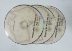
SPECIAL ADDED FEATURE: As a supplement to the printed drawing lessons, I have recorded (in my basement workshop– I don’t have access to expensive video equipment) videos of each drawing lesson. If you or your student has trouble following step-by-step pictures (which I know are troublesome for some types of learners) you can watch the video of the lessons to get the general idea of how to do the drawing. PLEASE NOTE: I’ve found that some people regard these DVDs as the main part of this whole curriculum. I consider them to be just a supplement, not the focus. Please don’t rely on just the video demonstrations. Have the printed versions of the lessons near at hand so you can refer to them for sharper images of sketch lines and labels.
Time needed to complete the curriculum: Personally, I would use this curriculum over the course of the entire year, using one chapter per week. I’d do the history lesson and drawing one day, and one or more of the activities on another day of that same week. However, you may use this curriculum however you want to. You may have a student who wants to zip through the drawings at a fast pace. That’s fine. Do whatever works for you.
FAQs:
—Can I use this curriculum in conjunction with another? Yes, the history lessons are brief, so it would not be too much for your student(s) to read other history lessons alongside these. A book that dovetails particularly well is “Around the World in 100 Years” by Jean Fritz.
— Can I just use bits and pieces of this curriculum without using the whole thing? You can use as much or as little of it as you want to. Just pick and choose what you want to use. Some people just choose the drawing lessons that are helpful at certain points in their own curriculum.
— Can I use this with multiple age groups? Yes. In fact, this curriculum is ideal for using with mixed ages. I’ve heard back from customers who have used this curriculum with students as young as 7 or 8 (although I really don’t recommend it for kids this young) and as old as 18.
— Can I use this curriculum with a group? Yes, it is great for using with a group. Even if you have no art skills at all, you can offer your group a geography drawing class. Just pop the DVDs into a DVD player and have the group watch the drawing lessons. This is especially helpful if your group has a very small budget and can’t require that each family purchase the curriculum themselves.
— Is the similarity of your title to “Mapping the World by Heart” intentional? Yes, somewhat. My curriculum was born out of my frustration and sense of disappointment with that curriculum. I determined I could do better. I knew that it was likely that many people had experienced what I had– thinking the curriculum was going to provide real instruction and finding it did not. (And I had already signed up for a whole year of teaching art and geography to a large group of kids, so I had no chioce but to write my own materials week by week.)
Additional information
| Weight | 0.2 lbs |
|---|---|
| Dimensions | 3 × 2 × .25 in |