Ellen McHenry's Basement Workshop
Search
11 item
  • Home
  • About
    • Ellen Bio
    • Ellen’s Tools and Tips
    • Art Portfolio
    • Contact
  • Free Downloads
    • Unit studies
    • Animals
    • Plants
    • Human Body
    • Earth Sciences
    • Chemistry
    • Physical Science
    • History/Social Studies
    • Bible History
    • Art
    • Geography & Maps
    • Math
    • Microbiology
    • Latin
    • Language Arts (English)
    • Drama
    • French
  • Music
  • Videos
    • Astronomy Art Videos
    • Botany Art Videos
    • Animal science videos
    • Invertebrates
    • Desert science videos
    • Map drawing videos
    • Art Videos
  • Updates
  • Store
  • Affiliate Area
  • Home
  • China Map Project
  • History/Social Studies, Ancient China, Geography & Maps
  • China Map Project

China Map Project

China Map Project

joakman2016-05-11T10:24:34-04:00
By joakman Ancient China, Geography & Maps, History/Social Studies

China Map Project

Chinamapfinal

Purpose of activity:

An introduction to the geography of China

Target age group:

Ages 9-13, but can be used with younger if they have help.

Description of activity:

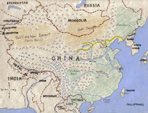
There are two layers.  The bottom is a colored map with cities and geographical site labeled.  The top layer is a clear transparency with the modern country lines on it.  The transparency can be lifted to see the land as it really is, without the political boundaries.  An extra page gives an outline of Texas and Pennsylvania that you can photocopy on the back of the map, to give a size  comparison so that students will understand how big China is.

Time needed:

At least 30 minutes.

Materials you will need:

colored pencils (I recommend Berol Prismacolor) or crayons, scissors, clear packing tape (“Scotch” tape will do), copies of the pattern pages on white card stock and transparencies (any office supply store can copy things onto transparencies), permanent markers (preferably red or orange or blue). 

Click here to download patterns and instructions

Share this post

Facebook Twitter LinkedIn Google + Email

Author

joakman

© Copyright 2000-2023 Ellen J Mchenry

Ellen McHenry's Basement Workshop © Copyright 2020. All Rights Reserved.